

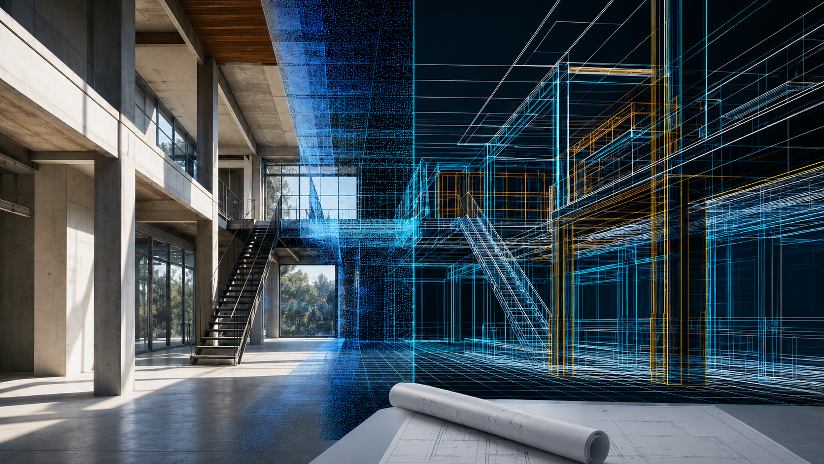
3D Gaussian Splatting (3DGS) har snabbt gått från att vara ett banbrytande tekniskt dokument till en vanlig produktionsstandard för verklighetsfångst. För yrkesverksamma som skapar digitala tvillingar av verkliga tillgångar erbjuder 3DGS oöverträffad fotorealism. Men i takt med att dessa arbetsflöden mognar till industriella och kommersiella tillämpningar har metoden som används för att fånga den underliggande rumsliga datan utlöst ett stort branschskifte.
Medan tidigt införande av 3DGS i hög grad förlitade sig på fotogrammetri (att sätta ihop hundratals vanliga 2D-fotografier), professionella 3DGS-arbetsflöden ersätter snabbt rena kamerametoder med aktiva SLAM LiDAR-hårdvaraHär är anledningen till att branschexperter uppgraderar sin datainsamlingsstam för att säkra verklig skala, hastighet och tillförlitlighet.
1. Skalproblemet: Eliminera den visuella illusionen
Fotogrammetri fungerar med en passiv linsbaserad metod. Den uppskattar objekts positioner genom att analysera pixelvariationer över överlappande bilder. Även om detta ger en vacker visuell kontinuitet, saknar det i sig fysisk djupdata. En digital tvilling som genereras enbart genom fotogrammetri förstår inte verkliga dimensioner utan den mödosamma manuella placeringen av fysiska skalstreck eller markkontrollpunkter (GCP) i fält.
Däremot, LiDAR (ljusdetektering och avståndsmätning) är en aktiv sensor. Den avger exakta Time-of-Flight (ToF) laserpulser som fysiskt mäter det exakta avståndet till ett mål millisekund för millisekund. I kombination med avancerade SLAM-algoritmer låser den absoluta rumsliga koordinater ($X, Y, Z$) direkt ur lådan.
Den tekniska verkligheten: För kommersiella platsundersökningar, fastighetsinspektioner eller Scan-to-BIM-arbetsflöden måste en 3DGS-modell vara mätbar. LiDAR-baserad 3DGS säkerställer att en 2 meter lång dörröppning mäter exakt 2 meter i den digitala tillgången, utan skalförskjutning eller strukturell distorsion.
2. Bearbetningshastighet: Från timmar till minuter
En av de dolda flaskhalsarna i arbetsflöden inom ren fotogrammetri är den kraftiga beräkningslatensen. Innan 3DGS smartmotor ens kan börja träna sina strålningsfält måste den köra täta Structure-from-Motion (SfM)-algoritmer för att justera de tusentals tagna bilderna. Detta steg är notoriskt långsamt och kräver ofta tunga stationära arbetsstationer eller dyra molnrenderingsfarmar för att bearbeta en enda tillgång under flera timmar.
SLAM LiDAR stör helt denna tidslinje. Eftersom den rumsliga justeringen sker i farten via hårdvara medan du går på platsen, är punktmolnsramverket redan strukturerat och rent. Genom att mata in förinställd LiDAR-geometri i din 3DGS-motor eliminerar du den massiva beräkningskostnaden för bildmatchning. Kontorets databehandlingscykel går från en halvdags väntetid till en högautomatiserad, minuter lång operation.
3. Miljömässig flexibilitet: Oberoende av ljusbegränsningar
Fotogrammetri kräver nästan felfri, enhetlig belysning. Skuggor, solljus med hög kontrast, reflekterande fönster och ytor utan formskillnad (som släta vita väggar eller långa, mörka korridorer) gör att fotogrammetrialgoritmer misslyckas. Resultatet blir flytande visuella artefakter, skeva strukturella gränser eller massiva geometriska blinda fläckar i den slutliga modellen.
Eftersom LiDAR genererar sin egen ljuskälla via aktiva lasrar, förblir den helt opåverkad av omgivande ljusförhållanden. Den kartlägger becksvarta miljöer, djupa skuggor och mycket komplexa tillgångskonfigurationer med exakt samma geometriska återgivning som ett starkt upplyst rum.
Hur FJD Trion-ekosystemet överbryggar klyftan
Den sanna framtiden för verklighetsfångst i företag är en hybridmetod: att använda LiDAR som det absoluta geometriska skelettet och högupplösta kameror som det realistiska texturöverlägget. Det är här professionell hårdvara förändrar spelet.
Apparater som FJD Trion P2 och den FJD Trion V4e LiDAR-skanner är uttryckligen utformade för detta integrerade arbetsflöde. Till skillnad från mobila konsumentlösningar som förlitar sig på djupsensorer med låg räckvidd och högt brus från smartphones, använder FJD Trion V4e LiDAR-skannern en dedikerad, oberoende inbyggd LiDAR-sensor i kombination med synkroniserade kameror. Den hanterar all rumslig positionering direkt och aktivt.
När du laddar upp dessa dubbla strömdata till FJD Trion Modellwebb plattformen använder dess smarta bearbetningspipeline det rigida, millimeterexakta SLAM LiDAR-punktmolnet för att låsa strukturen. Den sprider sedan sömlöst den synkroniserade bilden över den exakta bildrutan. Slutresultatet är en verklighetstrogen, hyperrealistisk digital tvilling i 3DGS som direkt kan delas via en vanlig webbläsare – redo för exakta tekniska mätningar eller omedelbara fjärrinspektioner.
Vanliga frågor (FAQ)
Varför kan jag inte bara använda en vanlig kamera för kommersiell 3DGS-modellering?
Medan en standardkamera fungerar för små, rent konstnärliga 3DGS-tillgångar, saknar den de fysiska data som krävs för kommersiella arbetsflöden. Utan en aktiv hårdvarusensor som LiDAR har den resulterande modellen ingen verklig skala, är benägen att deformeras geometriskt och kräver långa bearbetningstider för att beräkna kamerajustering manuellt.
Förbättrar SLAM LiDAR den visuella kvaliteten på 3D Gaussisk Splatting?
Ja. Genom att tillhandahålla ett ultraprecis, brusfiltrerat strukturellt ramverk hindrar SLAM LiDAR den smarta 3DGS-motorn från att skapa flytande visuella artefakter och "suddiga" geometrier, vilket ofta uppstår i ren fotogrammetri när bildjusteringsalgoritmer kämpar med komplexa eller dåligt upplysta miljöer.
Kan FJD Trion-hårdvara bearbeta 3DGS-modeller automatiskt?
Ja. Genom att ladda upp synkroniserad LiDAR- och bilddata som samlats in av FJD Trion P2- eller V4e LiDAR-skannern till FJD Trion Model Web-plattformen hanterar den smarta molnmotorn den komplexa 3DGS-pipelinen automatiskt och levererar en webbklar, interaktiv digital tvilling utan behov av lokal avancerad grafikhårdvara.
Matterport till CAD: Alternativ för redigerbara DWG- och DXF-ritningar
Hur man konverterar handhållna LiDAR-punktmoln till Revit BIM-modeller snabbare