

The concept of the "Digital Twin" has evolved far beyond basic 3D CAD shapes and static structural frameworks. Today, industrial, commercial, and engineering professionals demand immersive, real-time virtual replicas that look exactly like the real world while maintaining absolute spatial precision. While 3D Gaussian Splatting (3DGS) has emerged as the premier choice for photo-realistic visual rendering, it requires a robust hardware framework to cross the line from a beautiful visual project into an enterprise-grade utility.
The true future of advanced reality capture lies in a smart hybrid ecosystem: elevating the hyper-realistic capabilities of 3D Gaussian Splatting by anchoring it to the millimeter-accurate skeleton of professional handheld SLAM LiDAR. Here is how this convergence is redefining digital twins for the next generation of asset management.
The Radiance Field Evolution and Its Missing Link
Traditional digital twins built on complex polygon meshes or textured photogrammetry models often suffer from rendering lag, blurry details, and a massive computational burden. 3D Gaussian Splatting disrupts this by using millions of soft, continuous 3D Gaussians (splats) to capture light reflection, transparency, and intricate textures seamlessly.
However, when 3DGS relies solely on passive imagery or consumer-grade cameras, it faces a major technical bottleneck: spatial drift and lack of true physical scale. An intelligent processing engine can guess colors and textures perfectly, but without an active hardware anchor, the model cannot verify real-world distances or withstand rigorous engineering assessments.
How V4e SLAM LiDAR Elevates the 3DGS Workflow
By inserting professional-grade SLAM (Simultaneous Localization and Mapping) LiDAR data into the 3DGS production pipeline, the entire reality capture workflow undergoes an intelligent upgrade.
1. Instant True-Scale Geometry
LiDAR uses active Time-of-Flight laser pulses to map physical space independently of ambient lighting. Because it physically measures real distances, the resulting point cloud serves as a mathematically perfect spatial skeleton. When 3DGS radiance fields are applied on top of this LiDAR spine, the final digital twin inherits absolute true scale automatically, allowing users to extract precise dimensional measurements directly from a web browser.
2. Eliminating Visual Warping and Artifacts
Purely visual photogrammetry models regularly suffer from "floaters" or geometric distortions when encountering reflective windows, dark corners, or featureless white walls. SLAM LiDAR actively resolves this by supplying a continuous, pre-aligned coordinate framework. The smart 3DGS engine utilizes this precise framework to lock the visual textures into place, eliminating floating artifacts and ensuring flawless geometric boundaries.
The FJD Trion Professional Ecosystem: V4e LiDAR and P2 scanner
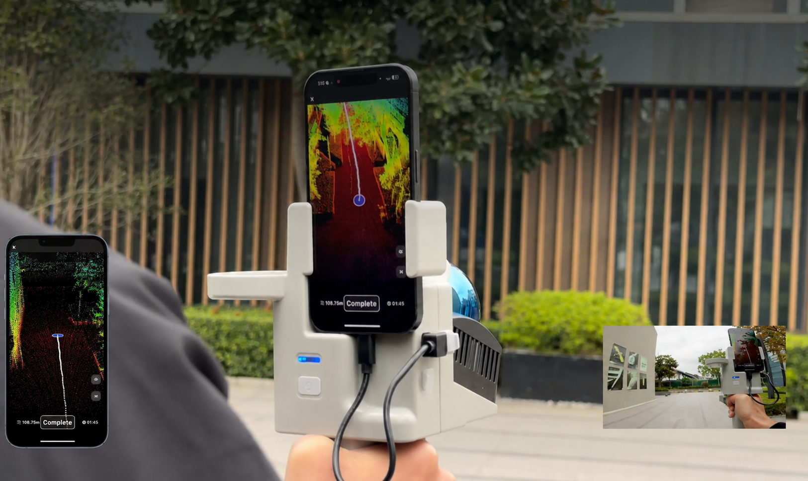
Executing this highly optimized hybrid workflow requires specialized hardware that captures both spatial metrics and high-resolution visual feeds simultaneously. The FJD Trion V4e LiDAR scanner and the high-performance FJD Trion P2 are purpose-built to act as the primary intake engines for this advanced pipeline.
Hardware Integrity: Unlike entry-level consumer mobile tools that attempt to scan environments using a smartphone's native camera or short-range consumer depth sensors, the FJD Trion V4e LiDAR features its own dedicated, built-in LiDAR sensor. It operates entirely independently of external device sensors, ensuring professional-grade point density, extensive range, and the structural fidelity needed for industrial digital twins.
For large-scale, high-density professional requirements, the FJD Trion P2 delivers robust, long-range SLAM performance, allowing operators to map massive infrastructure, multi-story buildings, and complex outdoor topologies rapidly without sacrificing accuracy.
Once the field scan is completed via a quick walk through the site with the V4e LiDAR or P2 scanner, the data flows effortlessly into the cloud:
- The raw scan data is uploaded directly to the FJD Trion Model Web platform.
- The platform's highly automated cloud engine extracts the rigid SLAM point cloud frame.
- The smart system then projects the synchronized imagery over the accurate frame via 3D Gaussian Splatting algorithms.
The final result is a stunning, web-ready digital twin that combines the absolute measurement accuracy of a laser scanner with the photo-realistic detail of a cinematic camera. This asset can be accessed, reviewed, measured, and shared globally through any standard web browser, unlocking true remote operation capabilities for enterprise clients.
Frequently Asked Questions (FAQ)
What is the benefit of combining SLAM LiDAR with 3D Gaussian Splatting?
Combining SLAM LiDAR with 3D Gaussian Splatting ensures that your digital twin is both visually photo-realistic and structurally accurate. The LiDAR hardware establishes the absolute, true-scale physical geometry, while the 3DGS engine provides rich, realistic textures, eliminating the scale drift common in pure imagery methods.
Can a 3DGS digital twin be used for actual engineering measurements?
Only if it is backed by hardware-grade active sensors like LiDAR. Models generated strictly from standard cameras lack physical coordinate baselines. When anchored by a professional SLAM scanner like the FJD Trion V4e LiDAR or P2 scanner, the model retains millimeter-level accuracy suitable for precise structural calculations.
Do I need an external device sensor to scan with the FJD Trion V4e LiDAR scanner?
No. The FJD Trion V4e LiDAR scanner features a fully integrated, independent built-in LiDAR sensor. It does not rely on or borrow accuracy from a smartphone's camera or consumer depth sensors, ensuring reliable, high-density data capture in any environment.
3DGS Digital Twins: LiDAR or Photogrammetry?
From Field Scan to Chief Architect: Delivering Instant 2D DXF Floor Plans Without the Subscription Tax