

The landscape of spatial data capture is evolving at a breakneck pace. Whether you are a professional surveyor, a construction manager, or a tech-savvy enthusiast looking for the latest tools in digital twin creation, understanding the nuances of indoor vs. outdoor LiDAR scanning is essential. Selecting a high-performance 3D laser scanner can be the defining factor between a project that delivers centimeter-level accuracy and one that falls short of industry standards. In this comprehensive guide, we will dive into the technical requirements of various environments and help you identify the best handheld LiDAR scanner for sale to elevate your workflow.
The Fundamental Mechanics of a Modern 3D Laser Scanner
A 3D laser scanner functions as the eyes of a digital recreation process. By emitting millions of laser pulses per second and measuring the time-of-flight for each pulse to return, the device creates a dense georeferenced point cloud. This data serves as the foundation for everything from floor plans to complex 3D models. When looking to buy 3D laser scanner technology, users often choose between static setups and a mobile mapping system.
The industry is currently shifting toward mobile solutions because of their sheer efficiency. A mobile mapping system allows the operator to move through a site at a walking pace, capturing data far more rapidly than traditional tripod-based methods. This speed is why many professionals visit a specialized LiDAR store to upgrade their equipment, seeking tools that offer all-in-one integration and high points per second output.
Indoor LiDAR Scanning: Mastering Precision in Enclosed Environments
Scanning indoors presents a distinct set of hurdles. From narrow corridors in residential buildings to the complex piping of industrial plants, indoor spaces require a 3D laser scanner that can navigate without the help of satellite positioning.
The Power of SLAM vs Traditional Surveying
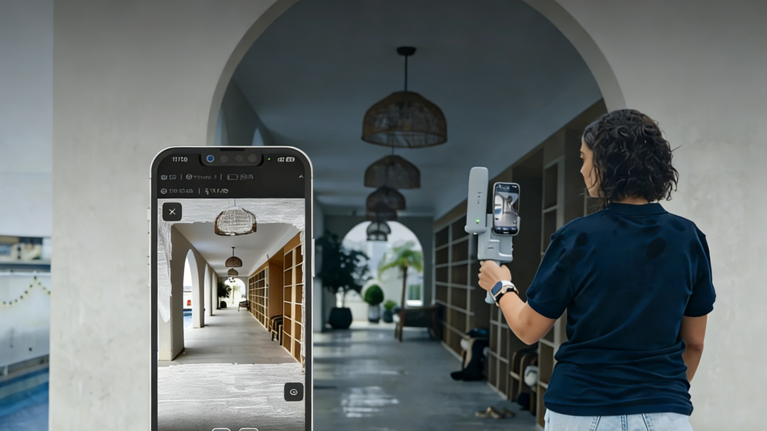
In an indoor setting, GPS signals are blocked by walls and ceilings. This is where the debate of SLAM vs Traditional Surveying leans heavily toward SLAM (Simultaneous Localization and Mapping). Traditional surveying requires setting up known control points, which is time-consuming. In contrast, a handheld LiDAR scanner using SLAM builds its own map as you walk, providing real-time visualization of the data.
For those looking for a 3D laser scanner for sale that excels indoors, the Trion P2 is a standout choice. The P2 is a portable / pocket-sized powerhouse designed specifically for interior mapping. Its ability to maintain centimeter-level accuracy without GNSS assistance makes it the ideal tool for BIM projects and indoor digital twin creation. When you buy a P2, you are investing in a device that simplifies the capture of complex indoor geometries.
Optimizing BIM Projects with High Precision
Building Information Modeling (BIM) relies on the "as-built" accuracy of a structure. Using a handheld LiDAR scanner like the Trion P2 allows architects to capture every corner of a room, ensuring that the georeferenced point cloud aligns perfectly with the physical space. This level of high precision is necessary to avoid costly errors during the renovation or construction phase. If you are looking to improve your efficiency, visit our store to see how the P2 can transform your indoor workflows.
Outdoor LiDAR Scanning: Tackling Distance and Global Positioning
Moving a 3D laser scanner outdoors introduces new variables such as direct sunlight, large open spaces, and the need for absolute geographic positioning.
Integrating an RTK GNSS Receiver for Global Coordinates
Outdoor mapping often requires the data to be tied to a specific location on Earth. This is achieved through an RTK GNSS receiver. When a mobile mapping system includes an RTK module, it can provide global coordinates for every point captured. This is a significant part of the RTK LiDAR accuracy benefits, as it allows for the seamless overlay of scan data onto satellite imagery or existing topographic maps.
For outdoor professionals, the Trion V4e series is the premier solution. Whether you choose the V4e Base for standard applications or the V4e Pro for more demanding tasks, these scanners are built to handle the rigors of the field. The V4e series is designed to be a versatile 3D laser scanner for sale that offers a long 50m scanning range, making it perfect for capturing large building facades or conducting a detailed forestry inventory.
The Challenges of Utility Mapping and Large Scale Sites
In utility mapping, accuracy is non-negotiable. You need to know exactly where a pipe or a power line is located. The Trion V4e provides the high precision required to map these assets across vast areas. Furthermore, the high points per second rate ensures that even thin wires or small markers are captured in the georeferenced point cloud. If your business involves large-scale land management or infrastructure inspection, you can buy online the V4e series to ensure your team has the best tools available.
Advanced Applications: Stockpile Volume and Forestry Inventory
One of the most common uses for a handheld LiDAR scanner in the outdoor sector is calculating stockpile volume. In the past, measuring a pile of gravel or coal was a manual, dangerous task. Now, with a mobile mapping system, an operator can walk around the perimeter and get an instant, accurate volume calculation.
Similarly, forestry inventory has been revolutionized. A 3D laser scanner can penetrate the canopy to map individual tree trunks and heights. The Trion V4e, with its robust outdoor performance, allows researchers to collect data in dense forests where traditional GPS might struggle, utilizing its internal SLAM to supplement the RTK GNSS receiver data.
Comparing the Trion P2 and the V4e Series for Your Business
When you visit our LiDAR store, choosing between the Trion P2 and the Trion V4e depends on your primary environment.
- The Trion P2: Best for users who prioritize mobility and indoor precision. It is the ultimate portable / pocket-sized scanner for real estate, interior design, and small-scale BIM projects.
- The Trion V4e Series: Best for those who need a rugged mobile mapping system that can transition between indoor and outdoor environments. With its 50m scanning range and integrated RTK capabilities, it is the professional choice for utility mapping and building facades.
Both systems offer real-time visualization, allowing you to check your data coverage on the fly. This feature alone reduces the need for return trips to the site, significantly lowering the cost of mobile mapping systems over the long term.
Technical Excellence: Field of View and Post-processing
A critical spec to look for when you buy 3D laser scanner hardware is the Field of View (FOV). A wider FOV means the scanner can see more of the environment at once, which improves the SLAM algorithm's ability to track its position. Both the P2 and V4e series feature an optimized FOV to ensure stable tracking in even the most challenging environments.
Furthermore, the data is only as good as the software used to analyze it. Our point cloud post-processing software ensures that the raw data is cleaned, filtered, and refined to achieve maximum post-processing accuracy. This software provides all-in-one integration, making it easy to export your files into industry-standard formats for further analysis.
The Economic Advantage: Why Buy a 3D Laser Scanner Now?
Many small to medium-sized businesses are concerned about the cost of mobile mapping systems. However, the current market offers more affordable options than ever before. By investing in a handheld LiDAR scanner, you are drastically reducing the man-hours required for site surveys. What used to take a team of three people two days can now be done by one person in two hours.
The Trion V4e and Trion P2 are positioned as high-value assets that provide a quick return on investment. Whether you are performing utility mapping or creating a digital twin, the speed and centimeter-level accuracy of these devices make them a smart purchase for any forward-thinking company.
How to Use Handheld LiDAR for Maximum Efficiency
To get the best results from your 3D laser scanner, it is important to follow a few simple steps. First, always ensure you have a "loop" in your walking path. This allows the SLAM software to recognize a previous location and correct any minor drift, ensuring the highest post-processing accuracy. Second, for outdoor scans with the V4e, allow the RTK GNSS receiver to gain a fix before you start moving to ensure your global coordinates are locked in.
For beginners, the real-time visualization on our mobile app is a lifesaver. It acts as a digital paintbrush, showing you exactly where you have already "painted" the environment with laser points. If you see a gap, you can simply walk back and fill it in before leaving the site.
Finding the Best LiDAR Scanner for Surveying in 2026
As we look at the current market, the best LiDAR scanner for surveying is one that balances portability, accuracy, and ease of use. The Trion V4e Base and V4e Pro represent the cutting edge of outdoor mobile mapping, while the Trion P2 remains the king of indoor versatility.
If you are ready to take your data collection to the next level, our store is open and ready to assist. We offer various 3D laser scanner for sale options tailored to different budget levels and technical requirements.
Conclusion: Transforming the Way We Map the World
The choice between indoor vs outdoor LiDAR scanning no longer requires two separate, expensive setups. With the FJD Trion lineup, you can find a mobile mapping system that bridges the gap. From the pocket-sized convenience of the Trion P2 to the industrial-strength capabilities of the Trion V4e, we provide the tools you need to succeed.
Visit our product page at https://store.fjdtrion.com/collections/product to browse our current inventory. Whether you need a scanner for BIM projects, forestry inventory, or utility mapping, you can buy online today and start capturing your world with centimeter-level accuracy. Don't settle for traditional methods when the future of 3D scanning is just a click away in our LiDAR store.
Can I Use an RTK Handheld Receiver with a Smartphone?
What Does the LiDAR Scanner Do?