

In recent years, LiDAR scanners have become essential tools in fields ranging from surveying and construction to digital twins and urban planning. But what exactly does a LiDAR scanner do, and why is it becoming so indispensable? This article will explore the workings of LiDAR scanners, their key applications, advantages, and guidance on purchasing the right device for your needs. By understanding the technology and its potential, you can leverage a LiDAR scanner for accurate, efficient, and highly detailed 3D mapping.
Understanding the Basics of a LiDAR Scanner
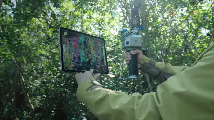
A LiDAR scanner is a device that measures distances by emitting laser pulses and analyzing the time it takes for them to return after hitting a surface. The result is a highly detailed point cloud that represents the scanned environment in three dimensions. This capability makes LiDAR scanners critical for applications where precise measurements are needed.
How a LiDAR Scanner Works
LiDAR, short for Light Detection and Ranging, operates by sending out rapid laser pulses. When these pulses hit an object, they bounce back to the sensor. The scanner calculates the distance using the time-of-flight principle, producing thousands or even millions of data points per second. These points are then compiled into a georeferenced point cloud, providing a detailed representation of the scanned environment.
Modern LiDAR scanners can operate in handheld, mobile, or stationary formats, offering flexibility depending on the application. Many devices also incorporate SLAM (Simultaneous Localization and Mapping) technology, allowing for real-time mapping in areas where GPS signals may be limited. RTK (Real-Time Kinematic) integration further enhances positional accuracy, making it possible to achieve centimeter-level precision for surveying or construction projects.
Different Types of LiDAR Scanners
There are several types of LiDAR scanners, each suited for specific tasks:
- Handheld LiDAR Scanners with RTK: Portable and ideal for indoor mapping, quick surveys, and small-to-medium sites.
- SLAM LiDAR RTK Scanners: Combine SLAM technology and RTK to generate accurate georeferenced point clouds in real time.
- GNSS RTK Laser Scanners: Used primarily outdoors, integrating GNSS data for accurate mapping over large areas.
- 3D Laser Scanners with GNSS RTK: Typically used for high-precision surveying and BIM workflows.
By understanding these types, you can select the LiDAR scanner that best fits your workflow, whether it's for construction, GIS, or digital twin applications.
Key Applications of LiDAR Scanners
The versatility of LiDAR scanners has led to their widespread use in multiple industries. Below, we explore the main applications.
LiDAR Scanners for Surveying and Construction
Surveyors and construction professionals increasingly rely on LiDAR scanners to capture accurate measurements quickly. These devices allow for detailed site mapping, ensuring structures are built to precise specifications. Handheld or portable RTK LiDAR scanners are particularly useful for site inspections, topographic surveys, and building measurements, offering an efficient alternative to traditional surveying equipment.
LiDAR Scanners in BIM and Digital Twin Workflows
LiDAR scanners are essential in BIM (Building Information Modeling) workflows. They provide highly accurate georeferenced point clouds, which can be imported directly into modeling software. This enables the creation of digital twins of buildings, bridges, or entire construction sites, facilitating better planning, design, and maintenance.
With devices like the V4e LiDAR Combo, users can integrate real-time SLAM scanning with RTK corrections to generate point clouds suitable for BIM applications, reducing human error and improving project efficiency.
Urban Mapping and Infrastructure Projects
Urban planners use LiDAR scanners to map entire city blocks, streets, and public infrastructure. With SLAM LiDAR RTK scanners, planners can obtain accurate, high-resolution 3D maps for traffic analysis, utility planning, and infrastructure maintenance. These scanners allow for efficient data collection in complex urban environments, including areas with limited GPS coverage.
Forestry, Mining, and Tunnel Applications
LiDAR scanners also find applications in forestry and mining, where understanding terrain and vegetation is critical. Similarly, tunnel construction projects benefit from portable LiDAR scanners that capture accurate 3D representations of underground spaces. By combining SLAM technology and georeferenced point clouds, engineers can ensure structural safety and monitor progress in challenging environments.
Advantages of Using a LiDAR Scanner
High Accuracy and Georeferenced Point Clouds
The primary advantage of a LiDAR scanner is its accuracy. Devices equipped with GNSS RTK or RTK LiDAR modules can achieve centimeter-level precision, producing reliable georeferenced point clouds that are suitable for professional surveying and construction workflows.
Efficiency in 3D Mapping
Traditional surveying methods can be slow and labor-intensive. LiDAR scanners significantly reduce time spent on-site by capturing millions of points per second, allowing for rapid 3D mapping. This efficiency enables teams to complete surveys faster while maintaining high-quality data for analysis.
Portability and Ease of Use
Handheld LiDAR scanners offer remarkable portability without sacrificing accuracy. Many models are lightweight, battery-powered, and require minimal setup, allowing users to scan spaces quickly and without the need for tripods or perimeter wires. Devices like the P1 and P2 LiDAR scanners combine portability with advanced SLAM and RTK capabilities, making them suitable for both beginners and professionals.
Choosing the Right LiDAR Scanner
Handheld vs Terrestrial Laser Scanner (TLS)
Handheld scanners are portable and convenient, ideal for small-to-medium sites or indoor mapping. TLS devices, in contrast, are stationary and often offer higher accuracy for large-scale projects. Evaluate your project requirements to choose between mobility and maximum precision.
SLAM LiDAR vs RTK LiDAR
SLAM technology enables real-time mapping in areas with limited GNSS signals, while RTK LiDAR scanners provide highly accurate georeferenced data. Depending on whether your priority is flexibility or absolute positional accuracy, you may choose a SLAM or RTK device—or a hybrid that combines both.
Range, Accuracy, and IP Ratings
LiDAR scanners vary in range, points per second, and durability. For outdoor use, an IP-rated rugged scanner ensures resistance to dust and water, protecting your investment. Check specifications such as range (e.g., 50m, 70m, or 120m), accuracy (1 cm or better), and IP rating to select the device that fits your environment.
Factors for Beginners and Professionals
Beginners may prefer user-friendly, handheld devices, while professionals might require advanced RTK or SLAM LiDAR scanners with software integration for BIM workflows. Always evaluate your workflow, required precision, and training resources before investing.
Tips for Buying a LiDAR Scanner
Where to Buy LiDAR Scanners
If you are looking to buy a LiDAR scanner, reliable online stores like ours offer a range of options suitable for both beginners and professionals. Our store features the V4e LiDAR Combo, P1, and P2 scanners with advanced RTK capabilities, ready for surveying, construction, and digital twin applications.
Popular Products and Their Features
- V4e LiDAR Combo: Portable RTK GNSS 3D LiDAR Scanner, ideal for fieldwork and BIM integration.
- P1 Handheld LiDAR: Compact SLAM LiDAR scanner, perfect for indoor and urban mapping.
- P2 LiDAR Scanner: Advanced RTK and SLAM capabilities, designed for professionals needing high precision.
Warranty and Customer Support
Most of our products come with comprehensive warranties and customer support, ensuring your investment is protected. Always check for warranty terms and after-sales service when purchasing a LiDAR scanner.
How to Get the Most Out of Your LiDAR Scanner
Setting Up for Accurate Data Capture
Ensure your scanner is correctly calibrated, with the correct coordinate system and datum settings. This is essential for generating accurate, georeferenced point clouds.
Using NTRIP and GNSS RTK for Optimal Performance
Integrating NTRIP corrections with RTK LiDAR scanners ensures real-time high-precision mapping, especially in outdoor environments. Proper setup maximizes accuracy and reduces post-processing time.
Post-Processing Point Cloud Data
Once data is collected, post-processing is critical. Software tools allow you to filter noise, align scans, and export to BIM or CAD formats. Many modern LiDAR scanners provide integrated workflows for smooth data management.
Integrating with BIM and Digital Twin Platforms
LiDAR scanners enable the creation of digital twins, offering a virtual representation of physical assets. Integrating point clouds into BIM platforms allows for accurate design validation, progress tracking, and maintenance planning.
Conclusion: Why You Should Consider Buying a LiDAR Scanner
A LiDAR scanner is more than just a measurement tool; it is a gateway to accurate, efficient, and versatile 3D mapping. Whether for surveying, construction, BIM workflows, urban planning, or industrial projects, investing in a high-quality LiDAR scanner can save time, reduce errors, and enhance project outcomes.
If you are ready to buy a LiDAR scanner, explore our store for professional-grade V4e LiDAR Combo, and P2 scanners. With advanced RTK and SLAM technology, these devices offer portable, high-accuracy scanning solutions to meet all your mapping needs.
Indoor vs. Outdoor LiDAR Scanning
How Accurate is LiDAR Surveying?